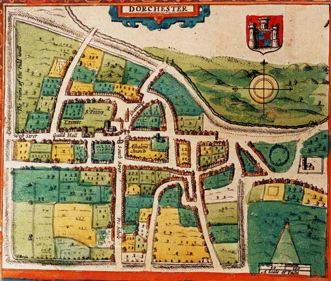
The earthen ramparts that nearly surround Dorchester can clearly be seen.
"In the neighbourhood of Dorchester are several stone bridges over the river Frome. On the north-west part of the town are Great and Little Mohun's bridges, near each other; so called perhaps from their founder one of the Mohun's of Wolveton. To the end of the latter is joined a causeway of paved stone, three or four feet high, extending almost to Burton. They were first ordered to be repaired by the county in the 7th year of the reign of Charles I (1631). About a mile eastward of these near Fordington is Stocking Bridge, which was ordered repaired by the county in 1689. Not far from this is a small but neat bridge of three arches (Known as Greys Bridge) on the new road into the town built by Mrs Lora PITT in 1747".
Today, a millstream branch runs south-southeast past today's Fordington Mill. It has a date stone of 1596 which presumably came from the old Mill shown on the map. In the book 'Dorchester Divided' published in 2002 it also says:-"After 1600 carts became more numerous and ways deteriorated faster. Impassable winter ways were abandoned every year. The important connection to London, north east from Fordington Mill via Stockham Bridge and on to Slyers Lane floundered in winter. Friary, Glippath and Mohun Bridges to Walton were frequently broken"
Nearly surrounding Dorchester can be seen the remnants of the earthen works where the old Roman Wall was. Only one very small section survives (see pictures) To the east the wall marked the boundary with the parish of Fordington where the Church of St George stands. To the North the wall followed the river with the parish of Frome Whitfield on the other side. This parish was united with that of Holy Trinity in 1610 by Act of Parliament as " It has for a long time been dispeopled and is now without parishioners, church or chapel". The Romans did much to shape Dorchester for the old Roman Wall, even though largely demolished by this date, left behind earthen embankments and between 1700 and 1712 they were flattened and turned into avenues of trees. These avenues are today referred to as "The Walks" and provide a delightful well shaded walk around two thirds of the town.St Peters The Rector of both St Peters and Holy Trinity from 1606 until his death in 1648 was the Rev.John White
Holy Trinity [referred to as Trinite]
All Saints [referred to as 'Alhalens church'] The Parson of All Saints from 1607 until his death in 1627 was Robert Cheeke. In 1617 he combined the role of Parson with that of Schoolmaster of the Free School which is also shown on the map.
St George's Church Fordington [unnamed but located on the far right hand side] The vicar from 1609 to 1616 was Rev William Jones and from 1616 to his death in 1643 was the Rev.Edward Pele
|
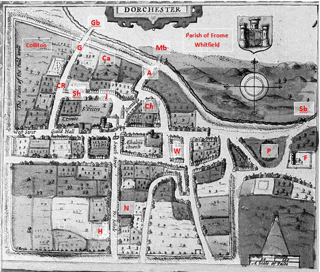
A - The Old Franciscan Priory 1267; built according to Speed from the ruins of the castle. Soon after this date bought by Sir Arthur Ashley JP who carried out extensive alterations.1 Ca - Castle Ruins later to become 'The Prison' CR - Colliton Row where Benjamin Devenish lived - behind which was situated the family home of the Churchill's at Colliton House Ch - Old Woman's Almshouse then in decay was the only Almshouse in Dorchester in 1611: later called Chubb's Almshouses after a benefaction from Margaret Chubb in 1620. It Housed 10 women in 16252. F - Fordington St George Church G - Glippath Gb - Glippath Bridge H- Hospital for education of the children of the poor J - Rev.John White's House Mb - Great & Little Mohun's Bridges named after their founder Mohun of Wolveton. Repaired 16311 N - Napper's Almshouses were not built until 1616 after the date of this map. Sir Robert Napper a Dorset landowner had begun building them in South Street prior to his death in 1615 and they were known as 'Napper's Mite' built 'to honour God'. They housed 10 poor men four from the country & 6 from the town.In 1636 William Cheeke the blind and feeble former rector of All saints was sent there. P - Fordington Pound Sb - Stocking Bridge (repaired 1689 - See Quarter Sessions Records Image 44 Order Books 1686-1699 on Ancestry.com) with its nearby Fordington Mill (Now called Swan Bridge) Sh - Sheep Street W - Whetstone's Almshouses operated from March 1621 (after the date of this map) for married couples - John Whetstone of Rodden left £500 in 1619 & house purchased in All Saints Parish.2 Genealogical Notes:- 1. History of Dorchester during the British Roman, Saxon and Norman periods by James Savage Published in 1837 Pages 155 - 161 2. Fire From Heaven Life in an English Town in the 17th Century by David Underdown published by Pimlico 1992. Pages 125-126 |