
Loders
|
Loders |
|
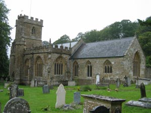 St Mary Magdalene, Courtesy of
Peter Walker |
Loders is a parish on the Asker river 2 miles
north-east of Bridport. It is a linear village, sitting in a long valley
between Waddon Hill and Boarsbarrow Hill, following the road between
Bradpole and Askerswell, with another road parallel to the river Asker.
The village is made up of three areas, in the west is Uploders with its
own public house and chapel. To the west of Uploders is Yondover, where
the village playing field is located. Further westwards is Lower Loders which has a public house, the church, village hall and a school. Lower
Loders is now generally known as Loders. |
|
|
| Census | 1841 Census [John
Ridout] 1861 Census [John Ridout] 1871 Census [John Ridout] |
| Parish Registers & Bishops Transcripts | Baptisms 1700-1715 [Jan Hibberd] 1731-1812, 1813-1880 [Bishops Transcripts] 1881-1905 [PR] [Pam Sharkey] Marriages 1636-1812 [Alan Bartlett] [Philimores] 1731-1833 [Emma Squires] [Bishops Transcripts] Burials 1731-1812, 1813-1880 [Emma Squires] 1881-1900 [Jan Hibberd] |
| Postal Directories | |
| Other Records | Protestation Returns 1641 [Tony Higgins] |
| Photographs | |
| Useful Links | Loders Church Roll of Honour [External] Loders Parish Council [External] |
| Monumental Inscriptions | St Mary Magdalene Monumental Inscriptions |
| Maps | The 1891
Ordnance Survey maps of the parish can be seen at the old-maps site, just enter 'Loders' under place search. For modern location maps visit:- www.multimap.com |
|
View Larger Map |
|
| Records held at the Dorset History Centre [Ref PE-LOD] |
Registers Christenings 1636-1991. Marriages 1636-1985. Burials 1636-1993. |
| Registration District (for the purpose of civil registration births, marriages, deaths & civil partnerships) |
1 Jul 1837-31 Mar 1997: Bridport 1 Apr 1997-30 Sep 2000: West Dorset 1 Oct 2000-16 Oct 2005: South & West Dorset |
Visitors to Dorset OPC
Copyright (c) 2024 Dorset OPC Project