Horton with Woodlands
|
|
Horton with Woodlands |
|
|
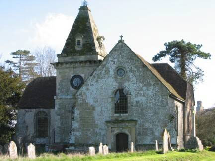
Horton is a village 6 miles North-east of Wimborne 5 miles West of Cranborne
and 2 miles East of Moor Crichel formerly in the Hundred of Badbury, division of Shaston E
and Union of
Wimborne and Cranborne. Horton was joined with the hamlet of Woodlands for Ecclesiastical
purposes. Recorded in 1033 as Hortun from an Anglo Saxon Chronicle Hortune
[DB}1086 Horton 1212 {Muddy Farm} OE horu+tun}. A monastery here was of the Benedictine Order, founded 961. The Priory was a
cell to Sherborne Abbey, Wolfryth the Abbess was a Saxon related to Alfred's Royal Line. There were
two mills recorded for flour and
grain in 6 acres of meadow with the River Stour flowing at the edge of the village. |
|
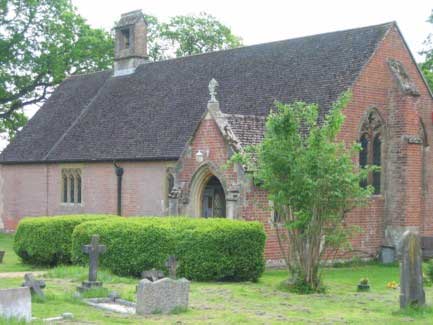
Woodlands hamlet
is close by and was formerly a Chapelry of Horton. Originally it had no Church but a building was licensed as a Chapel.
In 1892 the Church of Ascension was constructed for the Countess of
Shaftesbury. Outside it looks like a chapel, brick and stone, but inside
it not only has elaborate High Church fittings, but also is unusual
because it was designed by Bodley to have two naves. Hastings and Napier Families were here. It has a tower built on a hill
here by H Sturt Esq. |
|
|
|
| Census |
Census in two parts: 1841 Horton & Horton Heath, Woodlands [Anne Preston] 1851 Horton & Woodlands [Anne Preston] 1861 Census 1871 Census [Christel Muncaster] 1881 Census [Terry Smith] 1891 Census 1901 Census |
| Parish Registers |
Baptisms
1700-1750,
1751-1800,
1801-1850 [Kim Parker] Marriages 1563-1754, 1754-1837 [Kim Parker] Burials 1700-1750, 1751-1800, 1801-1850 [Kim Parker] |
| Bishops Transcripts Please note that the BTs here are extracts by the Transcriber only, and years may not be complete |
Baptisms
1741-1788 &
1798-1831 [Anne Preston] Marriages 1739-1812 [Anne Preston] Burials 1739-1799 [Anne Preston] |
| Trade & Postal Directories | |
| Other Records | |
| Photographs | |
| Monumental Inscriptions | Index of Monumental Inscriptions for the Church of Ascension, Woodlands [Jan Hibberd] |
| Maps | The 1891 Ordnance Survey maps of the parish can be seen at the old-maps site, just enter 'Horton' under place search. |
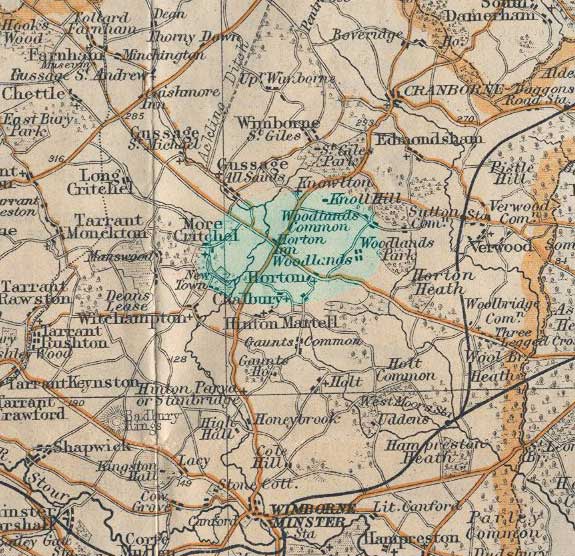 |
To see a 1920s map of the area click on the thumbnail on the left [91Kb] |
|
View Larger Map | |
| Records held at the Dorset History Centre Ref PE-HOR] |
Registers (Horton) Christenings 1563-1993. Marriages 1563-1974. Burials 1563-1962. Banns 1760-1994 |
| Registration District
(for the purpose of civil registration births, marriages & deaths) |
1 Jul 1837-31 Mar 1937: Wimborne 1 Apr 1937-30 Jun 1956: Blandford 1 Jul 1956-31 Mar 1997: Poole 1 Apr 1997-17 Oct 2005: East Dorset |
|
|
|
|
Visitors to Dorset OPC
Copyright (c) 2025 Dorset OPC Project