 |
Nowhere |
|
|
Nowhere |
|
|
|
Kington
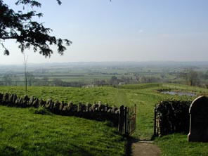
Magna is a parish and village 7 miles west from Shaftesbury in the Blackmore Vale.
This area was described by Thomas Hardy as the "vale of little dairies" and even
today dairy farming dominates the landscape. The western edge of the parish is part of the border with
Somerset, above is the small parish of
Buckhorn Weston, to the north
east is Gillingham,
West Stour is to the South. |
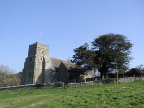
The Church of All Saints is in the Early English style and has a square embattled tower.
Parts of the church are Norman, it underwent a restoration in 1862. The registers date
from the year 1660. In 1851 a Primitive Methodist chapel was built in the village; it was on
Chapel Hill, which runs parallel to Church Hill. A National School was built in 1854 for 100 children. |
|
|
|
| Census |
1841 [Lynda Mudle-Small] 1851 1861 1871 [Christel Muncaster] 1881 [Terry Smith] 1891 [Linda Naranjo] 1901 |
| Parish Registers |
Baptisms 1670-1812 [PR] [Kim Parker] Marriages 1672-1841 [PR] [Kim Parker] Burials 1670-1812 [PR] [Kim Parker] Baptisms Marriages 1731-1834 [BT] [Christine Benger] Burials 1733-1743 [BT] [Christine Benger] |
| Postal Directories | Kelly's Directories for 1865, 1895, 1935 |
| Monumental Inscriptions | Index of names occurring on Burial Memorials |
| Other Records | Wills Proven at Blandford |
| Photographs | Photographs of the church and surrounding area |
| Maps | |
|
View Larger Map |
|
| Records held at the Dorset History Centre [Ref PE-KIM] |
Registers Christenings 1670-1966. Marriages 1671/2-1966, 1968-1985. Burials 1670-1978 |
| Registration District
(for the purpose of civil registration births, marriages & deaths) |
1 Jul 1837-31 May 1895: Wincanton 1 Jun 1895-31 Mar 1937: Shaftesbury 1 Apr 1937-31 Mar 1974: Sturminster 1 Apr 1974-17 Oct 2005: North Dorset |
Visitors to Dorset OPC
Copyright (c) 2025 Dorset OPC Project