
Manston
|
Manston |
|
|
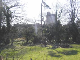
Manston The Parish of Manston on the River Stour is two miles North East of Sturminster Newton. In clockwise order from the north the parish is adjacent to Marnhull, West Orchard, Child Okeford, Hammoon, Sturminster and Hinton St Mary. The church of St Nicholas is an ancient structure in the style of the 11th century, it comprises chancel, nave, north aisle, south porch and western tower. The church was restored in 1885 and seats 200 people. |
|
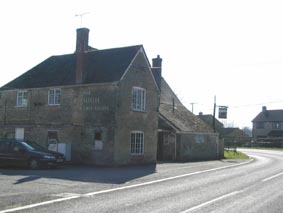
The parish registers date from 1614. There was a Wesleyan chapel in the parish. Manston House is said to be a handsome structure built on the site of an old manor which was destroyed in a fire in 1857. The soil is gravel, sand and loam and is mostly down to pasture. The area is 1323 acres. A mixed school was built in 1848 for 40 pupils. The population in 1851 was 131; in 1861, 135; 1871, 168; 1881, 187; 1891, 193; 144 in 1931 and 180 in 2001. |
|
|
|
|
| Census | Census are on-line for 1841, 1851, 1861, 1871, 1881, 1891, 1901 |
| Parish Registers | Baptisms 1724-1880
Marriages 1724-1846 Burials 1720-1881 |
| Postal Directories | Kelly's Directories 1855, 1867, 1875, 1880, 1895, 1935 |
| Monumental Inscriptions | St Nicholas Monumental Inscriptions index |
| Militia Records | Militia Ballot Lists 1796-1799 are available, to be transcribed |
| Land Tax & Land Owners | Land Tax Assessments 1790 to 1830 and Owners of Land 1873 |
| Manston School | Extracts from the School Log for 1889-1891 |
| The Workhouse | Details of residents from Manston in the local Sturminster Newton Workhouse at census time. |
| Photographs | A further 16 Photographs of Manston |
| Churchwardens Accounts | 1762-1876 to be transcribed or indexed |
| Overseers Accounts | 1821-1879 to be transcribed or indexed |
| 15th & 16th century records | Tudor Subsidies are available |
| Other Documents | Journal of Henry Kaines, Farmer & Diarist, 1768-1840 [Transcribed & annotated by Peter Shirley] [Very large pdf file, ~1.5MB] |
| Maps | The 1891 Ordnance Survey maps of the parish can be seen at the old-maps site, just enter 'Manston' under place search. |
| Records held at the Dorset History Centre [Ref PE-MAN] |
Registers Christenings 1626-1636, 1649-1650, 1657-1694, 1702-1997. Marriages 1620-1637, 1661, 1665, 1669, 1681-1996. Burials 1626-1639, 1661, 1666-1992. |
| Registration District (for the purpose of civil registration births, marriages, deaths & civil partnerships) |
1 Jul 1837-31 Mar 1974: Sturminster 1 Apr 1974-17 Oct 2005: North Dorset |
Visitors to Dorset OPC
Copyright (c) 2025 Dorset OPC Project