
Chalbury
|
Chalbury |
|
|
Chalbury is a small village in East Dorset in the Hundred of Badbury, four miles north of Wimborne Minster, five miles from Blandford and four miles west of Verwood. The name is believed to have derived from the fine shale which covered the area. It includes the tything of Didlington. In 2001 the population was 140. The Church of All Saints dates from the 13th Century, the interior is of great age with locked Box Pews of wood for the gentry, and some of simpler construction at the rear to accommodate the working class. In 1293 the Church lands and priory belonged to the Abbess of Wilton. Remarkable views are available from three sides of the church with Horton tower prominent. The little church itself is white-washed with a red tile roof, and although the chancel and parts of the nave are 13th century the overall impression is 18th century. The Folly or Lookout Tower was built by Humphrey Sturt of More Crichel.
|
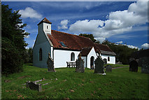 All Saints Church - Chalbury © Copyright Mike Searle and licensed for reuse under this Creative Commons Licence.
|
Please include the words "OPC
Chalbury" in the subject line of your messages |
|
| Parish Registers | Baptisms
1813-1851 [Jan Hibberd] Marriages 1813-1837 [Rachel Kent] Burials 1813-1983 [Jan Hibberd] |
| Bishops' Transcripts |
Baptisms Marriages Burials |
| Census |
1841 Census [Rosemary Valentine] 1861 Census [Royston Clarke] 1881 Census [Terry Smith] 1901 Census [Keith Searson] |
| Other Records | Monumental Inscriptions from
All Saints Church [Jan Hibberd] Rectors of the Parish of Chalbury [Jan Hibberd] |
| Photographs & Pictures | Some excellent photographs are available on the
Strolling Guides site Chalbury is featured in the January 2011 edition of Dorset Life |
| Maps | |
|
View Larger Map |
|
| Records held at the Dorset History Centre [Ref PE-CHY] |
Registers Baptisms 1629-1697, 1716-1992. Marriages 1629-1664, 1676-1691, 1716-1993. Burials 1629-1698, 1716-1992. Banns 1760-1982. |
| Registration District
(for the purpose of civil registration births, marriages & deaths) |
1 Jul 1837-31 Mar 1937: Wimborne 1 Apr 1937-30 Jun 1956: Blandford 1 Jul 1956-31 Mar 1997: Poole 1 Apr 1997-17 Oct 2005: East Dorset |
Visitors to Dorset OPC
Copyright (c) 2025 Dorset OPC Project